Evening beside the Bow River at Calgary’s Pearce Estate Park.Gulls are returning to roost on mid-river islands. Kayakers play in man-made rapids beside a diversion weir that tilts river water out to wet the farm fields of Alberta’s Western Irrigation District. Joggers and strollers explore trails through the cottonwood forest surrounding the Sam Livingston Fish Hatchery and the Bow Habitat Station. Redwings sing in the wetland at the heart of William Pearce’s former family estate.
It’s a scene Pearce could view with pride—the future he once imagined. Pearce knew that Alberta’s prosperity would depend on the living waters that drain from Alberta’s foothills and Rocky Mountains—that’s why he fought for watershed conservation all his life. But today his pride would likely be leavened by disappointment: our rivers bring less water now than they did in his day, even as demand for water grows.
Shortage of water means Alberta’s ambitions may soon exceed its grasp. It’s not like Pearce didn’t warn us.
William Pearce arrived in Calgary in 1884, determined to make sure Canada didn’t mess up its West. Farther south, waves of eager Americans were fighting over water holes, shooting at the indigenous people, laying waste to forests and overgrazing the plains. That kind of chaotic settlement was not, in Pearce’s opinion, an option for what was then Canada’s northwest.
His opinion mattered. As superintendent of mines for the CPR “Railway Belt,” Pearce controlled most land-use decisions in the region surrounding the new Canadian Pacific Railway. Appointed by the Deputy Minister of the Interior in faraway Ottawa, Pearce soon became known as the “Czar of the West.” He established new parks, settled land disputes, allocated mineral rights and recommended settlement and development policies.
Pearce had spent his youth in well-watered southern Ontario, so he was struck by the scarcity and small size of our prairie rivers, as well as their unfortunate habit of shrinking each summer just as water demand peaked. He knew that the West’s agricultural potential would be limited by available water. It didn’t help that the 1880s had been marked by drought; if the skies couldn’t always be relied upon for water, he reasoned, the rivers must provide it.
Pearce consequently became a keen champion of irrigation development. But even as he explored the potential for dams and canals to carry water to prairie farms, he looked west to the Rocky Mountains and foothills. That was where the water came from. Nothing, he decided, could be allowed to diminish or threaten the headwaters.
Pearce succeeded in getting the forests along the edge of the Rocky Mountains reserved as public land in 1898 to protect the watershed. Settlement and development were prohibited. He went on to persuade the Canadian government, in 1902, to enlarge adjacent Banff National Park to 12,691 km2, twice its modern size. When later governments shrank the park to exclude resource-rich areas, they redesignated the deleted land as an addition to the forest reserve.
The reserve included the forested headwaters of the Oldman, Bow, Red Deer, North Saskatchewan and Athabasca rivers. The Department of the Interior’s 1911 report described it as “a timbered area lying alongside of a prairie country hundreds of miles in extent… form[ing] the watershed for the river systems which water the great plains to the east, where water supply is practically the only limit to anticipated settlement and development.”
Real estate speculators, cattlemen and loggers had ambitions for reserve land. But Pearce’s vision won. The undisturbed forests, beaver meadows and relict glaciers were set aside to gather and store water from winter snows and spring rains. That way they could always be relied on to release water slowly, through soil seepage and deeper groundwater aquifers, to the cold springs and creeks that feed the downstream rivers. Watershed protection trumped all.
That’s been the rule—on paper—ever since. When the forest reserves became part of Alberta’s “Green Area” in 1948 and were put under joint federal–provincial administration, new legislation reiterated the primacy of water supply over other uses. In the 1970s Alberta resumed full responsibility for managing its headwaters; its policy for resource management of the Eastern Slopes again put watershed protection first.
With over a century of such enlightened public policy, one might expect the headwaters of our prairie rivers to be in good condition and our water future assured. One would be wrong.
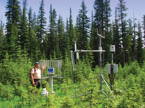
John Pomeroy at the Marmot Creek research station in Kananaskis Country. (Kevin Van Tighem)
Marmot Creek, just north of Kananaskis Country’s Nakiska ski area, drains some of those headwater forests. Researchers have studied its watershed since 1943. I visited in 2012 with John Pomeroy, a hydrologist from the University of Saskatchewan.
Why would a Saskatchewan professor be interested in Alberta’s high mountain forests? Almost all the water in the South Saskatchewan River, Pomeroy explained, comes from Alberta’s Rocky Mountains. In fact, more than 90 per cent of all western stream flows in North America come from the mountains west of the Mississippi River—mostly from melting snow. If you’re concerned about prairie water, you need to pay attention to what Pomeroy describes as the “snow forests.”
The population of Alberta and Saskatchewan has increased more than ninefold in the past century. Meanwhile, river flow in the South Saskatchewan has declined more than 40 per cent. Although irrigated farming and other human water uses explain some of the loss, about 30 per cent of the missing flow remained unaccounted for. That raised questions that led Pomeroy to his river’s headwaters, in Alberta.
Historically, the preferred solution to water supply problems was not to study the headwaters but to build dams—for example, the Gardiner Dam on the South Saskatchewan in 1967, the Dickson Dam on the Red Deer in 1975 and the Oldman Dam in 1989. But dams don’t make water; they simply store what is already available. At best they enable water engineers to hold some of the spring runoff until summer, when it’s needed. At worst, however, leakage and evaporation actually reduce the supply.
Diefenbaker Lake, behind the Gardiner Dam, is southern Saskatchewan’s biggest source of stored water—three-quarters of that province’s population relies on it. Even so, evaporation takes more water from the reservoir than all those human users. It’s the same in Alberta. Up to a metre of water evaporates from each of Alberta’s irrigation reservoirs each year. Monitoring of the Oldman reservoir has showed that it loses a litre of water to evaporation for every 100 L flowing into it. In short: Dams waste water.
Even so, in the mid-20th century the Alberta government’s water engineers came up with an ambitious solution for the thirsty south. The Prairie Rivers Improvement and Management Evaluation (PRIME) scheme proposed numerous dams and diversion canals to direct northern waters south. The bizarre scheme actually made a kind of sense; after all, 80 per cent of Alberta’s water is in the north, while 80 per cent of water demand is in the sunnier south. But, faced with widespread public outrage, successive Alberta governments have rejected interbasin water transfer.
In any case, diminished flows in the Athabasca and Peace rivers are now colliding with increased demand for water for bitumen mining and well-fracking. The North needs its water, not only to keep its rivers healthy but to meet its own future needs. Southern Alberta and Saskatchewan are going to have to solve their own water problems.
Pomeroy’s solution doesn’t involve dams. It involves finding the missing water. Based on forest hydrology research at Marmot Creek and other study sites, Pomeroy and his students have generated some likely ideas. (Kevin Van Tighem)
Part of the explanation goes to climate change. Alberta’s glaciers have shrunk by 25 per cent over the past quarter century. Glacial meltwaters can be particularly important in summer when rivers, deprived of spring runoff, would otherwise shrink. In fact, accelerated rates of glacier melt may be masking the effects of climate change by releasing stored glacier water faster than it’s replaced. Once the glaciers are gone—possibly by the end of this century—that subsidy will fizzle out.
Overall, though, glaciers contribute little to river flows. The Bow River gets only about 2 per cent of its annual flow from glacier melt. Less than 5 per cent of the North Saskatchewan is from glaciers.
Glacial ice retreat, however, is a proxy for what matters a lot more to river levels: snow accumulation. With warming temperatures, more winter precipitation falls as rain that runs off instead of being stored by mountain snowpacks until spring. Snow now melts out of the foothills up to two months earlier than it did in 1970—a startling change over so short a period.
Changes to Alberta’s forests provide another part of the explanation. Aggressive fire protection increased the amount of forest steadily through the 20th century. The amount of old forest in the headwaters today far exceeds the historic norm. Dense, continuous forests are neither natural nor good for water production.
To explain why, Pomeroy led us through a mossy glade into dark woods redolent with the scent of resin and hushed by the wistful whistles of varied thrushes. There he showed us a dead spruce tree hanging from a tower. Its sawed-off trunk ended just above the ground. Cables and posts held various instruments at different levels of the surrounding forest canopy as if a mad arborist were conducting bizarre experiments.
Pomeroy was quick to explain the tree-lynching. To determine how much snow the forest canopy intercepts each winter, the researchers fell a tree, hang it in its normal growth position and then weigh it periodically throughout the winter. The technique has yielded some startling findings. Thanks to chinook winds, it turns out, Alberta’s headwater forests lose more canopy snow to sublimation—the evaporation of water directly from solid snow to water vapour—than anywhere else in the world. Sublimation can remove as much as 60 per cent of the snow trapped on tree branches each winter. This is a big loss.
Thus, very little canopy snow becomes meltwater in the spring; it goes aloft again and vanishes into distant weather systems. The denser the forest, the more snow gets trapped in the branches of trees. Snow that accumulates on the ground, on the other hand, especially if protected from sun and wind, loses far less moisture to sublimation. Instead, the spring snowmelt feeds groundwater and streams. So the tree canopy is not all bad news—a good scattering of mature trees helps the underlying snowpack melt gradually in the spring rather than all at once.
Hydrologists have found that clear-cut logging can increase the winter snowpack as much as 40 per cent. The increased snowmelt yields up to a 12 per cent increase in stream flows. Unfortunately, since the unprotected snowpack melts quickly, that comes mostly as more-intense spring floods.
Research findings from Marmot Creek suggest that forest managers hoping to optimize the water supply from managed forests should thin the forest, not clear-cut it. The only place for clear-cuts, if water is the priority, is on steep slopes sheltered from direct sunshine or wind. Promoting deciduous regrowth instead of the more commercially valuable spruce and pine also would improve water yield. Aspen and poplar trunks reflect about 20 per cent of incoming sunlight. Conifers reflect 8 per cent at best. The rest becomes radiant heat that hastens the snowmelt.
But that’s not how foresters log. Even though the policy priority in our headwaters is watershed health, logging companies manage for wood, not water. You can’t blame them; it’s how they define their business, and it’s what the Alberta government insists on. They could log for water instead of wood fibre—but who would pay?
Gord Lehn doesn’t consider that question insurmountable. He’s director of communications and ecological goods and services for Spray Lakes Sawmills.
Many governments prohibit logging in the headwaters of major cities, but Spray Lakes holds cutting rights upstream from Calgary and in almost the entire Oldman drainage. I was curious about what Lehn’s company is doing to protect the water-holding capacity of so critical, and limited, a landscape. A few days after visiting Marmot Creek I called Lehn with an offer: I’d bring lunch if he’d show me what Spray Lakes was doing for the watershed.
On a golden September day, we headed out to look at old cutblocks and current logging operations in the Elbow River headwaters. I soon concluded that Spray Lakes could be proud of their practices. Commercial-scale logging is never pretty, but their work is exemplary compared to other companies that continue to degrade the headwaters farther north.
Even so, logging as it’s done in Alberta is not good for watersheds. Government regulations, and market imperatives, require companies to remove as much wood as possible before scarifying the logged-off areas and replanting them with new spruce or pine. They bulldoze haul roads across easily eroded slopes, force small creeks into culverts that block fish from spawning areas, and they clear-cut trees from large cutblocks.
Roads increase runoff and erosion both by stripping away the vegetation that intercepts rain and snowmelt and by creating new drainage routes where runoff erodes the exposed soil. Where logging roads cut into steep banks, they often bring shallow groundwater to the surface as new, temporary springs. As surface water, it drains out of the landscape faster than if left to seep slowly through undisturbed soil.
Lehn reassured me more than once during our day in the woods that logging increases water yield; lessons from Marmot Creek, however, have made it clear that it’s not that simple.
The snow in large clear-cuts melts quickly. The water all rushes off the landscape in early spring, eroding muddy gullies before hitting downstream creek channels with punishing floods that destabilize their floodplains. Then the water’s gone.
Where shady forests used to soak up snowmelt over weeks and gradually release shallow groundwater into springs and seeps through the summer, keeping creeks cool and well watered, the open clear-cuts bake in the summer sun, their soils now deprived of moisture that ran off too soon. Creeks become shallow and sun-warmed. Downstream water users complain of increasingly intense spring floods and more frequent summer droughts—signs of a sick watershed.
Some of what Spray Lakes Sawmills does helps reduce the risk to the headwaters. For example, I could find no culverts on any of their temporary roads. Lehn explained that, although Alberta’s forestry rules permit culverts on smaller channels, Spray Lakes’ own standards prescribe a bridged crossing over any stream channel, even if it only flows for part of each year. Bridges prevent damage to stream floodplains by keeping the water and streambed connected.
The logged areas we visited were too large and had been clear-cut, but they were well laid out, with uneven edges and patches of uncut trees. Spray Lakes processes each tree right where it’s cut, leaving the branches to help shelter the soil and contribute to vegetation regrowth. Once finished, the company pulls out the bridges and recontours most of the roads, reconnecting shallow groundwater flows rather than leaving them bleeding out of sidehill cuts.
But none of that seems to help Spray Lakes’ reputation. Operating in scenic areas that attract thousands of hikers, bicyclists, anglers and hunters every year, the company is under attack on all sides. Most controversial is their stubborn insistence on clear-cutting the headwaters of the Castle River—an area recognized for decades as worthy of protected park status, and one that yields almost a third of the Oldman River’s water. Public opposition is so fierce that in 2012 the Alberta government deferred further logging there pending completion of a South Saskatchewan regional land-use plan.
The company also faces opposition to its logging plans west of Bragg Creek and on the east flanks of the spectacular Livingstone Range, which extends from the Crowsnest to the Highwood River. Aesthetic, wildlife and water concerns continually eat away at the company’s social licence to operate. Lehn’s job title reflects Spray Lakes’ need for more friends: logging for “ecological goods and services” sounds more palatable than clear-cutting the headwaters.
Lehn agrees that Spray Lakes Sawmills could put watershed optimization ahead of wood supply in their planning, but not under traditional business models. Water shortages farther downstream might, however, offer new revenue options. Okotoks, for example, established a population growth cap in 1998 due to its limited water supply. The town recently set that cap aside when development outside the town boundaries rendered it moot. Removing the growth cap, however, doesn’t solve the water problem—it worsens it. Some town councillors want to dam the Sheep River.
Dams are massively expensive and massively destructive. They gradually become obsolete, too. Once built, their reservoirs begin to fill with silt, especially if the upstream watershed is unhealthy.
Lehn wonders why the provincial government couldn’t redirect the money it seems always able to find for dams to the kinds of forestry that increase the water supply. Reinventing forest management, based on lessons from Marmot Creek and other forest-hydrology research sites, could increase water yield and the timing of water flows in places like Okotoks at far lower costs—both economic and ecological.
The benefits of such an investment wouldn’t all flow down the rivers, either. Opening up the forest canopy, ensuring that no roads remain when cutting is completed and keeping the headwaters landscape moist well into the summer would also be good for grizzly bears, moose, trout and other species that thrive in sheltered green places. Healthy headwaters with thriving wildlife and clean creeks are the finest of places for human recreation too.
Grizzly bears, moose, trout and clean water, however, don’t thrive amid muddy, eroding trails. The last part of our tour took us into the McLean Creek watershed, a sad example of recreational mismanagement.
Forest managers hoping to optimize the water supply from managed headwaters should thin Alberta’s forests, not clear-cut them.
Dirt bikes, snowmobiles and all-terrain quads began to appear in Alberta’s headwaters country in the 1970s. Off-road vehicle (ORV) users quickly spread a web of eroding motor trails all through the landscape. Many of those trails cross streams repeatedly, muddying them with runoff. Worse, many ORV users are not content with easier access to fishing, hunting and scenery: they see the headwaters as a big playground. Mud-bogging has turned once-lush wetlands into muddy sumps. Some creeks have become de facto racetracks.
Faced with motorized anarchy in the woods, the Alberta government decided to try to regulate use by establishing some sacrifice areas. In 1979 the McLean Creek watershed, along with the Ghost–Waiparous farther north, were turned over to the ORV crowd as Forest Land-Use Zones (FLUZes). The idea was to provide a network of authorized woods trails for motorized vehicles. The rest of the landscape would be out of bounds. It didn’t work; anarchy prevails.
Lehn showed me logging haul roads that Spray Lakes Sawmills had recontoured and replanted only to see off-roaders develop new trails there. In one clear-cut, based on Alberta government guidelines, the company had to leave an unlogged buffer along a pre-existing ORV trail. The trail is a deeply eroded gully that funnels sediment and runoff directly into a once-healthy trout stream. Spray Lakes, whose operational guidelines try to minimize their impact on streams, was required to protect an ORV trail that functions as an open wound.
Out-of-control ORV use shreds watersheds all through Alberta’s headwaters. A 2006 Alberta Environment water quality study of Waiparous Creek, a tributary of the Ghost River, found that the Waiparous, which drains an ORV-riddled FLUZ, receives 10 times more sediment loading than the very similar Elbow River—the result of erosion from vehicle trails.
The Ghost River Watershed Alliance, a stewardship group of local ranchers and acreage owners, subsequently commissioned the consulting firm ALCES, led by noted landscape ecologist Brad Stelfox, to evaluate the entire Ghost drainage. Their 2010 report revealed that the Ghost watershed has 2,780 km of cutlines, roads and other linear features, of which 93 per cent are used by ORV riders. This is almost four times more than Alberta Environment and Sustainable Resource Development, which manages the area, had previously identified. In fact, only 189 km of trail is officially available for ORV use; all the rest is being used illegally. Riders disturb 14 times as much ground as they are allowed to.
The average ORV trail has an unvegetated surface up to three metres wide. Cumulatively, then, as much as 775 hectares of bare ground is exposed to erosion every time it rains in the Ghost drainage. If all the illegal trails were closed and revegetated and only the authorized trails left exposed, almost 720 hectares of new vegetation would hold snow and absorb rainfall. That would go a long way toward eliminating the erosion that turns the once-pristine Waiparous muddy brown after each foothills rainstorm. It would yield more, and better, summer water.
Given that the study area covered only a small part of Alberta’s trail-streaked headwaters, the potential for watershed restoration by closing ORV trails is enormous.
Turning illegal trails back to nature would also reduce Alberta’s carbon dioxide loading in the atmosphere. The US Environmental Protection Agency estimates that reforestation of bare land to conifers sequesters up to 2.1 tonnes of carbon per acre each year. Revegetating the Ghost watershed’s unauthorized ORV trails alone could pull more than 3,550 tonnes of carbon out of the atmosphere annually.
That might be a good use for some of the cash that oil companies pay for carbon credits. It might also help make up for all the carbon dioxide generated by OHV users continuing to enjoy access to authorized trails each weekend.
The Waiparous joins the Ghost River west of Cochrane and its muddy waters soon vanish into the reservoir behind TransAlta’s Ghost Lake Dam. There the silt settles to the bottom of the reservoir. The value of a reservoir is measured by how much water it stores, not how much silt; the Ghost Reservoir’s useful life is being dramatically shortened by ORV landscape abuse.
That’s too bad, because another part of the solution to southern Alberta’s water supply crisis may lie in hydropower reservoirs like the one behind the Ghost Dam. Those who persist in seeing dams, rather than healthy watersheds, as the answer to water shortages frequently point out that the Bow, unlike the Oldman and Red Deer rivers, has no large water storage impoundments. They are wrong. TransAlta manages almost a dozen dams upstream from Calgary, with a total storage capacity exceeding half a million acre-feet. That’s a lot of water storage, but it’s used to generate electricity during peak demand periods, mostly in the winter, rather than to sustain river flows and meet peak water demand in summer.
TransAlta is in the power business, not the water business. Electricity prices are highest in the dark and cold of winter; we need water most in summer. TransAlta could be in the water business, though. But as with Spray Lakes Sawmills, it would require a new business model with new revenue streams—either public investment or, possibly, some of that carbon cash. Healthy riparian systems, after all, sequester carbon.
A 1990s modelling study into how hydropower operations might be changed to restore the lakes and rivers they damage showed that “repurposing” just one dam, at Lower Kananaskis Lake, could triple the reservoir’s biological productivity, restore the Kananaskis River’s once-famous fishery, reduce winter ice jams and significantly increase summer water levels in the Bow through Calgary. TransAlta would still produce as much electricity, but not the most profitable peak-demand winter power. The change would cost the company close to a million dollars in forgone annual revenues.
Building the Oldman Dam cost almost $800-million in today’s dollars. Where water is concerned, money can be found, at least for non-solutions. The next dam, should there be one, will certainly cost in excess of a billion dollars. That’s 10 times what it would cost to compensate TransAlta for changing how it releases water from Lower Kananaskis Lake each summer, for the next century. Similar improvements in summer flows are possible from hydro dams on the Spray, Cascade and North Saskatchewan rivers.
There is at least one way to put a lot of dams into the headwaters at no cost to the public treasury. All that’s needed is a restricted quota or a total ban on the trapping of beavers in Fur Management Zone 6. Currently, licensed trappers there can kill all the beavers they want.
Beaver dams evaporate water too, but in the sheltered headwaters where air and water are cooler and the reach of the wind is limited by trees, the losses are much less than from vast sheets of reservoir water spread out beneath the sun and wind of the outer foothills. Besides, beaver dams store much of their water underground in riparian aquifers and wetland fens. The stored water drains from the landscape slowly, feeding cold water into streams well into summer or even into subsequent years. Research in the Beaver Hills near Edmonton shows that streams draining beaver-filled landscapes still had running water after several years of drought, long after nearby streams had gone bone-dry. If water matters, it makes little sense to continue trapping so valuable an animal—one that builds and maintains dams for free. Its ecosystem services are surely worth more than its fur.
Downstream water-users complain of increasingly intense spring floods and more frequent droughts—signs of a sick watershed.
The key to improving the water supply from Alberta’s foothills and mountainheadwaters is to capture as much of each winter’s snowfall as possible and to delay the release of snowmelt and rainwater from the high country until well into the summer. Current approaches to logging, off-road motorized recreation, hydropower production and trapping, however, do just the opposite. Ironically, those activities are all regulated by government agencies whose policy priority, for more than a century, has been to put watershed health above everything else. They’ve just failed to do so.
Logging for water would restrict clear-cuts to slopes sheltered from wind and direct sunlight. On more exposed slopes, loggers would thin the forest to reduce snow losses from canopy snow while retaining enough shade to protect the enhanced winter snowpacks. They would remove roads to eliminate the sidehill cuts that bring shallow groundwater to the surface. Where possible, they would promote regrowth of aspens and poplars rather than conifers.
The cost of this kind of logging would be higher and profits from wood production lower than from traditional forestry. If companies can’t make money, they won’t survive. Still, those companies have the skills, equipment and, in some cases, corporate cultures that suit them for the work. What they need is customers—for ecological goods and services, not for wood. Those customers are downstream, facing water shortages so severe that the government won’t issue new water licences. They’re just used to shopping for dams rather than for restored, healthy watersheds.
Those same customers could also pay companies like TransAlta to release more water from their upstream reservoirs in summer, which would provide improved flows, mitigate late summer droughts and help downstream rivers heal from decades of hydraulic abuse. In countless other valleys, beavers will do the same thing for free if we allow them to.
No amount of careful resource stewardship and business innovation, however, can restore Alberta’s headwaters to their full potential if every seismic cutline, cow trail or abandoned logging road is open to abuse by off-road vehicles. A limited number of off-road trails makes sense; allowing recreational anarchy to continue turning wetlands into mudbogs, eroding hillsides and choking streams and reservoirs with silt does not. Riding an off-road vehicle is fun for some; water is life for all.
William Pearce would have no illusions about which public value should trump the other, just as he would not dispute the value of investing public funds in enhanced watershed stewardship. At a time when a naturally water-scarce region, booming population growth and warming climate are converging to create a real-time water crisis for Alberta, neither should we.
Naturalist, hunter and former Banff National Park superintendent Kevin Van Tighem has studied Alberta wildlife for 40 years.
