by Ted Binnema, François Lanoë and Heinz W. Pyszczyk
University of Alberta Press
2025/$39.00/232 pP.
When it comes to navigating in unfamiliar terrain, today’s travellers have many options based on GPS systems. I’m a bit of a luddite with my boat anchor of an iPhone, but it does have the county map on it showing every quarter section of land, and landowner’s name, for miles around. If all else fails, I have topo maps for old school route finding, thanks to generations of cartographers who have plotted the entire country in a series of grids based on calculations of latitude and longitude. But in Cartographic Poetry we learn that Indigenous people, the Siksika and Gros Ventre, had a totally different way of navigating, based not on mathematical measurement but on landmarks, particularly rivers, that were, and are, of cultural, historical and spiritual significance. The authors note that “Poetry is language condensed: Siksika cartography is landscape distilled,” that is to say, not only landmarks but the history of a nation was distilled in the minds of the First Nations travellers and guides. Every river, every mountain, every buffalo jump was a living story in the mind of the people.
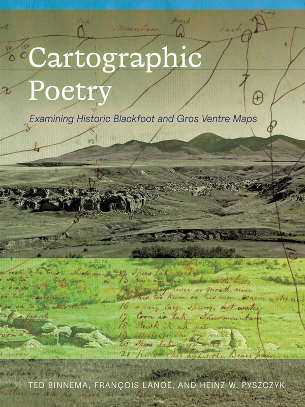
This was the mental cartography the early fur traders relied on, while exploring the west with Cree and other Indigenous guides. One notable explorer was Peter Fidler, a Hudson’s Bay Company surveyor and map maker. In 1792, guided by Sakatow and his band of Piikani, he made a winter journey from Buckingham House on the North Saskatchewan River south to the Oldman River gap. Nearly a decade later he established the short-lived HBC trading post of Chesterfield House, where he asked the Siksika leader Ac ko mak ki (Old Swan) to draw a map of the land south of the post, an area that at the time was a blank spot on European maps. Fidler, writes author Ted Binnema in one of his chapters, took great care in getting his guides to draw on paper the maps they held in their minds. Among explorers in that era, he “was unique in his systematic efforts to preserve and document Indigenous cartographic conventions.” Indeed, Cartographic Poetry contains a wealth of ethnographic detail on place names thanks to the meticulous care Fidler took with his Siksika and Gros Ventre informants.
The maps drawn for Fidler are very different from the European tradition of mapping. They are minimalist by necessity, since they would have been typically drawn in the snow, in sand or mud, or upon a piece of hide using charcoal or other medium. They show the Rockies, the “Back-Bone of the Earth” to the Piikani people, as a pair of double lines in Alberta bending east to the Musselshell River in Montana and then south again to the Big Horn Mountains. From it, the major rivers are drawn simply as lines leading out to the plains with the Indigenous names attached by Fidler. We are then shown their transition in Fidler’s hands to maps a fur trader might understand. Next, this Indigenous knowledge passes from the HBC to the famous British cartographer, Aaron Arrowsmith, for his 1802 map of North America. The authors point out that Fidler, if allowed, would have made a much better map than Arrowsmith. The latter, to “…make his depiction plausible to a western reader, invented sinuous river courses and confluences even though he had no evidence for them.” His map was relied on by Lewis and Clark for their much-ballyhooed continental transit in 1804 (which had already been done with zero fanfare by Alexander Mackenzie in 1793), but Arrowsmith’s map “…contributed nothing to the success of the Corps of Discovery.”
Today these maps “are priceless treasures,” write the authors. In publishing them they hope others will “become as fascinated by the maps, their authors and the territories they depict as we are.” With this respectful, evocative study, they have succeeded.
Sid Marty’s most recent book is Oldman’s River, which won the Al and Eurithe Purdy Poetry Prize in 2024.
_______________________________________
